Center
Mirador De Morro Velosa
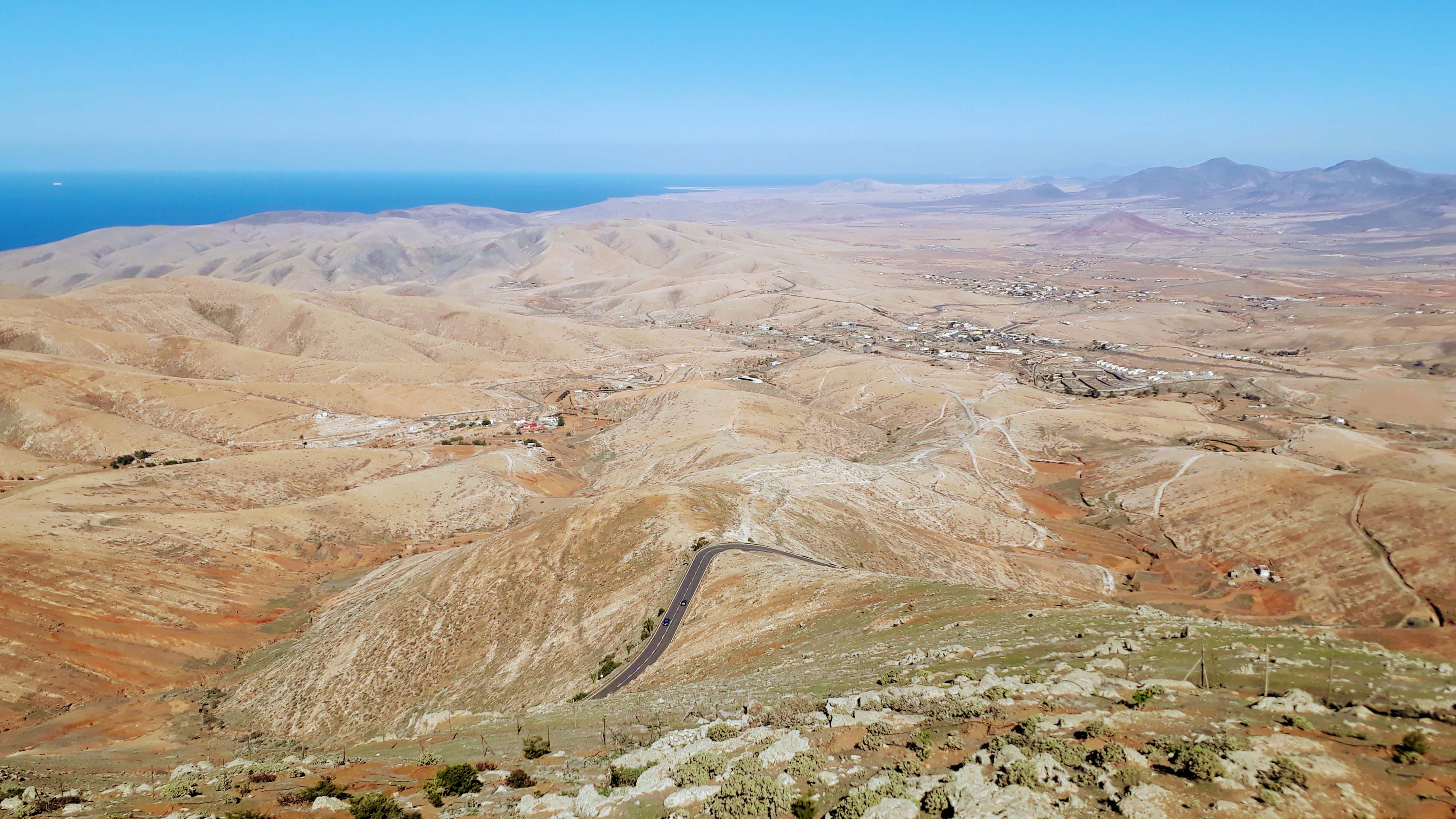
Of course, we don’t want to deprive you of the best viewpoint of Fuerteventura. The Mirador de Morro Velosa designed by César Manrique is located at an altitude of approximately 645 meters on a volcanic cone and offers an all-round panorama over the canary island. It also shows the more rural parts of the interior of the island, which was declared a UNESCO biosphere reserve. Ocher-colored hills, winding gorges and dreamy villages can be admired here without sand dunes and tourist centers.
BETANCURIA

As already mentioned, Betancuria was once the capital of the island. The village is also considered the historically most significant site of Fuerteventura. It is named after its founder Jean de Béthencourt, who began in 1402 under Henry III the conquest of the Canary Islands for Castile. Since then, the Canaries have been politically part of Spain. With only 710 inhabitants, the municipality is today the least populated of the island.
VEGA DE RÍO PALMAS
Near Betancuria, the village of Vega de Río Palmas, in English “meadow at the palm river”, is located. Terrace cultivation is still partly operated here and groundwater is pumped into the fields surrounded by clay walls with the help of windmills. The SL-FV-27 trail leads to the Presa de las Peñitas reservoir.
MIRADOR DE LAS PEÑITAS

From the viewpoint Mirador de Las Peñitas, the green oasis around the small lake in the middle of the desert landscape can be observed very well. It was created by the occurrence of the underground river under the ravine Barranco de Las Peñitas to the surface. The open esplanade of the overlook is the perfect place to stop off on the tour through the interior of the island and to enjoy the refreshing landscape.
ANTIGUA
Also Antigua was the island capital in the years 1834 to 1860 and is one of the oldest municipality of the island. To visit there is the 18th-century church of Iglesia Nuestra Señora de la Antigua, as well as the handicraft center Centro de Artesanía in the windmill Molino de Antigua. Every year in May, the Feria Insular de Artesanía crafts fair takes place.
CALETA DE FUSTE

In the town of Caleta de Fuste on the east coast of Fuerteventura, just a few kilometers south of the airport, we rented an apartment for one month. Besides Corralejo, Costa Calma and Jandía Playa, it is one of the tourist centers of the island. Based on old military maps, the bay was called El Castillo> (“castle”), referring to the still existing fortifications from 1740, which should offer the residents protection from pirates. Today, the town is inhabited mainly by tourists, mostly from Great Britain, in large hotels and apartment buildings.
SALINAS DEL CARMEN

South of Caleta de Fuste is the Salinas del Carmen salt extraction plant, where the white gold was extracted until 1980. The today’s salt museum informs with an exhibition about production and trade of the valuable resource. In the basins of the outdoor area, visitors can then observe salt in various stages of drying.
CENTRO DE INTERPRETACIÓN DE LA ATALAYITA

Atalayita is an archaeological site whose origins go back to the indigenous people of Fuerteventura, the Mahos. The village is located in the Pozo Negro valley in the eastern part of the island. It occupies an area of 1200 square meters and consists of numerous structures, mainly shards of pottery decorated by natives, skeletal remains and stone tools.
AJUY

On the west coast of the island lies the remote fishing village of Ajuy. North of the small bay, a path leads in the cliffs past the old lime kiln and the ship ramp. The particularly pure rock was burned and shipped from here until the 19th century. Due to bloody pirate attacks, the black beach bears the sobriquet Playa de los Muertos – “beach of the dead”.
CUEVAS NEGRAS

Just beyond, the bay Caleta Negra opens up to 600 meters deep caves. Those who dare can climb into the dark tunnel, where pirates once hid their booty.

PÁJARA
Pájara is the southernmost of the six municipalities of Fuerteventura. The eponymous village itself seems like an oasis in the valley between 600 meters high mountains. Here is the 1733 finished church Nuestra Señora de Regla. To the left of the church is the Centro Cultural de Pájara with the local library. Opposite presents the town hall (Ayuntamiento) itself in a modern appearance. Today there is even a communal freshwater swimming pool in Pájara, a real luxury on the dry canary island. In the center you will also find the Casa del Artesano, where you can visit Canarian craftsmanship.
MIRADOR ASTRONÓMICO DE SICASUMBRE
About 12 kilometers south of Pájara, you’ll find the astronomical viewpoint of Sicasumbre. Info boards inform along the way to the sundial, from which you have a distant view to the Jandía Peninsula at the southern tip. Moreover, there are star charts with the location of the main constellations. Amateur astronomers can bring their telescopes and cameras with them, because in Sicasumbre there is the possibility to install them.
GRAN TARAJAL

With 7323 inhabitants, Gran Tarajal is – after Puerto del Rosario and Corralejo – the third largest town of the island. There is no mass tourism like in Morro Jable or Corralejo, although it has a beach of dark sand and a beach promenade with a few shops and restaurants. The roads FV-512 and FV-511 lead to the mountain village Las Playitas and to the Punta de la Entallada.
FARO DE LA ENTALLADA
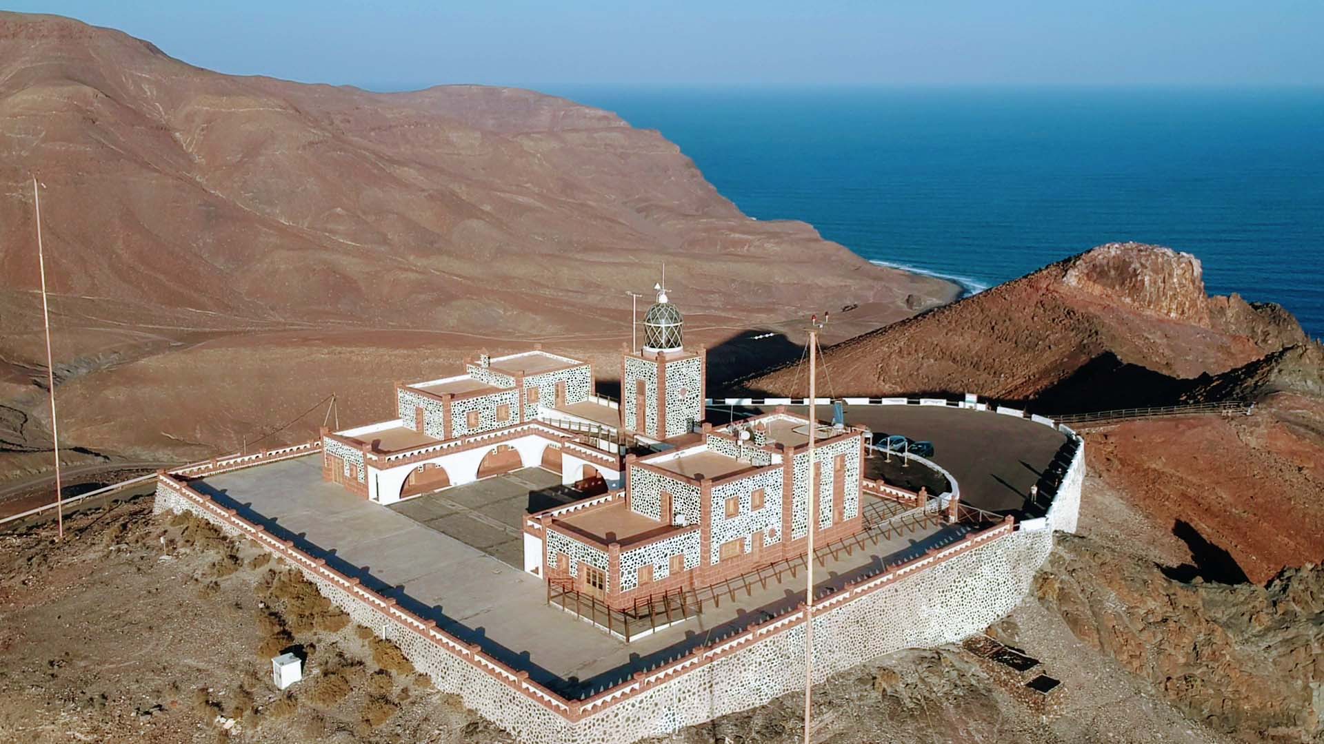
Here, the lighthouse Faro de la Entallada stands right on the cliffs at an altitude of 185 meters. It was built in 1920 and has a lantern tower that is untypically low for a lighthouse. This is due to its location high on the mountain, which results in an optimal view of the Atlantic and it is still well seen by ships.
Unfortunately, you can’t visit the automated lighthouse itself, but a path leads to the offshore overlook point Mirador de la Entallada. From the small viewing platform you can enjoy a wonderful view of the coast, the Atlantic Ocean and the Cuchillos de Vigán valley.
Here you get to the remaining sights of Fuerteventura and a few supermarket tips.